Laid

The nickname of “Croppies” was associated to the Laid population while the people of Durness were called “Machairich” or field people. A walk around the crofts and close inspection under areas of overgrown heather reveals remains of primitive dwellings. These are usually tucked in the side of little hillocks and close to the loch. There is also evidence of clay workings with small limestone kilns.
A small gabled former school and schoolhouse built in 1894 of local rubble, reddish-tooled dressing and tall chimney stacks is now a holiday home. The role was about an attendance of forty children at that time. The school was frequently used for dances and occasional weddings. There are many stories of a hard but happy life style in this community. Kelp was harvested in this area for the manufacture of soap and glass to supplement wages but returns for hard labour were very small. It was not until September 1982 the first mains electricity arrived in Laid.
In 1965, the township of Laid was not given very good recount, described as “artificially sited with crofting having never been successful and the township can be considered a failing community.” More recently with the advent of diversification on the Laid crofts, moves are afoot to re-establish Laid with its own identity and turn around the situation of neglect and decline. In March 1998 for the first time, a Laid Grazing Committee was elected by the shareholders of Laid Common Grazing. As well as aiming to produce a town development plan, efforts are underway to form geology and heritage trails.
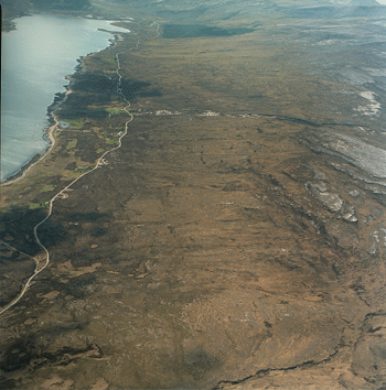
A township created in 1832-1835 to settle some subtenants from Eriboll and to relieve congested settlements established elsewhere after evictions; for some of the original inhabitants of Laid, this was their second enforced movement within a few years. A long defile of single and one and a half storey cottages, set on a rugged and rocky coastline .on the A838 Durness to Tongue road. Each cottage, many now ruins or replaced with modern bungalows and a patch of land, enclosed by a massive dry-stone dyke constructed of stone cleared from the land to create patches of soil able to be cultivated. A rocky near lunar landscape and barren land contrasting with the greenness of Eriboll on the east side of the sea loch. The sea loch with diverse and plentiful supplies was the main provider of food.


